Alberta's WaterIntroductionPublications Climate Change Industrial Impacts Agricultural Impacts Urban Impacts Biodiversity Loss Definitions Links Site Map |
 |
Alberta's WetlandsThis map shows the proportion of land in Alberta that is considered wetland. The prairie potholes in the southern area of the province were formed during the last glaciation on the Great Plains of south-central Canada and north-central United States. They are generally small, less than 50ha, but are abundant. Greater than 50% of these have been lost, with the largest contributor to their demise being agriculture.
|  | ||
 |  |
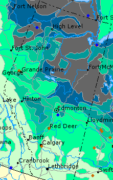
 < 5%
< 5% 5 - 10%
 10 - 25%
 25 - 40%
 40 - 65%
 > 65%
> 65% Water Area
 RAMSAR Sites (Sites listed under RAMSAR Treaty for Wetland Protection)
 Migratory Bird Sanctuary