The
use of maps in a game format provides review and reinforcement of map reading
skills. These games have been created by Dr. Joe Kirman, Webmaster of the
Canadian Social Studies Super Site, for your use. These games are under
copyright but may be copied for non-commercial classroom and personal use.
Commercial use requires permission and a license from the Webmaster. These games
can be used from elementary through the lower secondary levels. They add a
measure of enjoyment and recreation to geography instruction.
Game 1 - MAP EXPLORATION (Grade level: 4 and up)
GAME 2 - THE LATITUDE, LONGITUDE—SPELL IT GAME (Grade level: 4 and up)
GAME
3 - URBAN MAP TAG (Grade level: 3 and up)
This
game has four objectives: teaching geographical locations, using map symbols,
applying the concept of scale, and developing map-reading skills. Teachers may
use the game in any unit in which maps are used.
Grade
level: 4 and up
Materials
for the game are easily obtained and made. They include
1.
a map of sufficient size to enable six students to cluster around it
(e.g.,
a highway map);
2.
a set of fifty cards, each naming a different map feature or place; and
3.
a cardboard marker for each player.
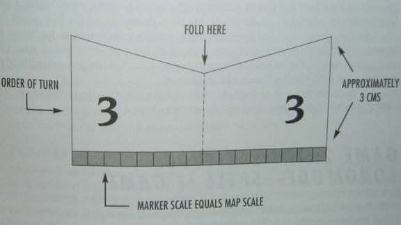
Number
markers in consecutive order. The numbers indicate the sequence of playing
turns. Make the base length of markers correspond to the map scale. Markers
should stand upright on the map (see figure 12-1).
Rules
for playing the game are as follows:
1.
Each of the six players draws a marker out of a paper bag.
2.
Each player draws five cards from the face-down deck.
3.
The game begins when players place the folded edge of their markers at
the center of the map. (An alternative starting point, such as a major city, may
be selected.)
4.
Players move their markers, turn by turn, to all places listed on the
cards.
5.
Players are limited to a maximum distance per move as specified by the
teacher in advance. The distance selected is influenced by the scale of the map.
6.
The players are allowed to move in any direction.
7.
The first player to reach all five places and return to the starting
point wins the game. If more than one player returns to the starting point
during a single sequence of turns, the game is declared a draw. This rule
eliminates the advantage players who draw lower marker numbers have.
The
game lends itself to the incorporation of several variations. For example,
different types of maps may be used, including Landsat images with selected
features identified on an acetate overlay.
Rather
than receiving cards, each child can select a number of places such as cities,
airports, or campgrounds, each of which has been given a point value by the
teacher. The first child to score fifty points is declared the winner. Interest
can be added to the game by giving players a set of mini-markers (e.g., popcorn
kernels) to put on places they have reached, thereby precluding the further use
of marked places for scoring by other students. In this option, each player
keeps a list of places reached and points scored. Each player, however, should
start at a different place to avoid giving undue advantage to those having the
first moves.
Another
option is to add a second deck of cards with penalties for delays imposed by
conditions common to the area (e.g., poor weather, flood, road construction,
heavy traffic) or rewards for moving an extra turn or going directly to the next
place. Cards may be drawn with each turn.
Yet
another option is to include cards of compass directions. These cards require
players to move in a specified direction or lose a turn.
Teaching
about latitude and longitude is a standard element in all elementary social
studies curricula. Once taught, it can be quickly forgotten unless it is
reviewed and reinforced. One way of doing this is to use it in a geography game
that can be played as soon as the children are able to plot latitude-longitude
coordinates. “Latitude, Longitude—Spell It” is a group game that does just
that. All that is needed for the basic game are a class set of coordinate cards
and enough maps for each group.
Grade
Level: 4 and up
1.
Divide the class into teams of three or four pupils. (Beyond this number,
group interaction is reduced.)
2.
Each team receives the same map and three to five different
latitude-longitude coordinate cards for locations on that map.
3.
There are two options. In Option A, the team finds the coordinates of
each card on their map and records the names of all cities and towns found
within a given radius of each coordinate. In Option B, the team locates the
closest city or town to the coordinates.
4.
Using the letters found in the names of those cities and towns, the team
arranges them to spell other cities and towns on the map.
5.
The latitude and longitude of each of these cities and towns are then
plotted by the team. Each correct coordinate scores one point for the team.
6.
A team representative then lists the names of the cities and towns with
their coordinates on the board. The other teams have the right to challenge the
accuracy of the coordinates and the spelling of the cities and towns. The
challenging team receives one point for each successful challenge that is
deducted from the score of the other team. An unsuccessful challenge results in
a point deducted from the challenging team and awarded to the other team. The
team with the highest score wins.
In
games such as this, there is usually only one winner. By chance, in Option A,
some teams may have greater numbers of letters to work with if their coordinate
cards have densely settled locations, or in Option B, some teams may have town
names with lots of letters. This may be considered an unfair advantage by some
of the children even if the cards were distributed in a random manner. To avoid
this, and to help keep class morale high, every team that scores a minimum
number, such as five new locations, should be considered a winner. The team
having the greatest number can be the “top winner.” It is also a good idea
to distribute the coordinate cards in a manner that will allow every team to be
a winner.
A
map with one degree increments of latitude and longitude is best if the class is
learning about minute divisions. You will either have to add the minute
divisions or teach the children to estimate them. You can provide divisions of
latitude and longitude and extend the lines across the map by either drawing the
lines on the map or drawing them on a clear acetate overlay that can be Xeroxed
for the class. Minute divisions can be marked in the margins in increments of
15’ to avoid cluttering the map with too many lines. If acetate overlays are
used, it is possible to mark all the coordinate card intersections of latitude
and longitude on the acetates. The younger children can then find which
coordinate points correspond to the ones on their cards with a measure of
accuracy. When using overlays, make sure that there are well-defined alignment
marks on them and a supply of paper clips to hold the acetates in place. These
overlays are useful when the class is working with atlases and geography book
maps that cannot be drawn on.
If
Option A, using the names of the cities and towns within a given radius, is
selected the children can find the radius of the coordinates with a ruler or a
pre-measured length of string. Some children, especially the younger ones, can
be given a small acetate sheet having a teacher-made, pre-measured radius circle
with a dot in it. The children place the dot on the coordinates’ intersection
and look for the cities and towns in the circle. The scale of the map and the
quantity of cities and towns noted on it will determine the length of the
radius. Option B, using only the names of the town or city closest to the
coordinate, avoids this step.
A
sample coordinate card would merely have the latitude and longitude noted on it:
Latitude 51°N
Longitude 113°W
With
the coordinates, either Option B of using the letters in the town’s name to
make up other names on the map, or Option A using all letters in locations
within a radius of the coordinates can be selected. If the radius option is
used, one card (depending on the density of locations noted on the map) may be
sufficient for each team. If the option of only using the town and city names
located by the coordinate cards is used, three or more cards may be given to
each team.
In
preparing the coordinate cards you can add bonus cards that give each team extra
letters, or give all teams the same extra letters by writing them on the board.
The
children may use each letter as many times as they wish to find new locations. A
restriction can be placed on the use of each letter, for example, three times,
to limit the number of new locations. This letter restriction can be an item for
a challenge in which a team uses a letter more times than is permitted. The
length of the game can be controlled by the letter restrictions and the number
of latitude-longitude coordinate cards distributed to the teams.
In
this case Option B of using the names of cities and towns located near the
coordinates has been selected. Each team receives three cards and is told to
find the closest city or town to the coordinates. The teams will use the letters
in these names to spell other locations on the map, and to determine the
latitude and longitude of the new locations. There are no restrictions on how
many times a letter may be used.
Three
cards, each with a coordinate, are distributed to the teams. One team receives
the following coordinates:
Latitude 51°N
Longitude 113°W
Latitude 53°30’N
Longitude 113°30’W
Latitude 53°N
Longitude 111°45’W
First,
the team finds the location on the coordinate cards. Second, they rearrange the
letters of these locations to spell other locations on the map. Third, they find
the latitude and longitude of the new locations. Fourth, they report to the
class by writing the new locations and their coordinates on the board and
receive challenges from the other teams.
The above are the approximate locations of Standard, Edmonton, and Viking, Alberta. Using the letters in these names, the team can arrange them to spell the following towns and cities found on a map of Alberta: Irma, Marsden, Amisk, Marengo, Ardossan, Gem, Red Deer, Morrin, Mirro. The team receives a point for each location with correct coordinates of latitude and longitude. (In this case a map of Alberta was used, but you can use any map.)
Depending
on the class level and pupil ability, you may wish to allow some leeway in the
coordinates of the locations reported by the children. For example, where a
location is not found directly on a meridian of longitude or parallel of
latitude, where an error would be very noticeable, an error of plus or minus
5’ latitude or longitude could be acceptable.
When
grouping the children for teams, you can place slower children together and give
them cards with less difficult coordinates to find, and perhaps bonus letters.
Teams made up of brighter children can receive cards that provide a greater
challenge for them.
Although
the teams are in a competitive game, you should resist any temptation to turn it
into a race against time or a first team to finish-last team to finish
situation. In a skill performance, such as this game, it can only lead to
mistakes and frustration. The objective is to have the children do the best they
are capable of and concentrate on what they are doing rather than the time or
the other teams.
In
planning for how much time to allot to the game, a rule of thumb is that the
younger the class, the more time will be needed. For example, fourth graders
should have at least five minutes per coordinate card, and at least 30 minutes
to rearrange letters and find the new coordinates. Also, the first time children
play a game, it usually takes longer than when they are familiar with its rules.
In
some cases rather than using a fixed time for each segment of the game, you can
move from team to team and observe what each has accomplished to determine if
more time is needed. The game can also be stopped and continued at another
period either before the letters are rearranged for new locations, before the
new coordinates are found, or before the teams write their findings on the
board. This procedure also reduces the block of time needed to play the game.
The
game can be used for an interesting homework activity if the pupils individually
do the letter rearranging and determine the new coordinates at home. The next
day the teams can meet to compile their lists and write them on the board for
the challenge.
If
the homework option is used, all children will need a map. This can be done with
a map in their textbook or with a class set of atlases. An alternative is the
use of a class set of travel maps such as those provided by government agencies,
travel agents, or motor associations. However, such maps can be quite large in
size, and maps larger than 8” by 10” do not lend themselves to use with
acetate overlays. You can use a segment of such a map. It may also be possible
to obtain duplication permission from the map’s copyright owner and duplicate
copies for each child.
Once
the unit on latitude and longitude is completed and the children have
demonstrated their ability to find coordinates, and they understand what this
means for map use, it is imperative that when maps are used latitude and
longitude be included for review and reinforcement purposes. Current events
discussions, for example, can be accompanied by map use and the latitude and
longitude coordinates found for the item under discussion. This element of
on-going review and reinforcement should be done with all map skills, but
especially so at the elementary level. This easy-to-make game will be of some
help to begin the review and reinforcement of latitude and longitude and will
provide a measure of enjoyment for the children.
This
is an easily constructed game designed to encourage familiarization with
specific street maps and to reinforce the understanding of compass directions.
It also encourages children to find locations on a map, to determine the most
efficient routes to a destination, to think spatially and to identify places.
These latter two items are part of the six essential elements of geography noted
in Geography for Life, National Geographic Standards 1994. The game can be used
in geography and social studies units dealing with neighborhoods, communities,
and cities, and wherever large scale urban street maps are used. Children who
have played this game have also found it to be an enjoyable recreational
activity.
Grade
Level: 3 and up
Number
of players: two
to four
Contents:
Street map with cardinal points of the compass marked on it (use only a large
scale map or one enlarged to a larger scale), 23 movement cards, popcorn kernel
place markers (one for each player). With older children the map can be mounted
on corkboard and map pins used for place markers.
Objective:
To get a specific
location on the map without being tagged.
Procedure
The
teacher determines a location objective for players on the map. It can be either
a landmark such as the school or an arbitrarily selected street location on the
center or at one end of the map.
Players
determine among themselves who will assume the role of tagger and the order of
turn by die, spinner, finger choosing etc.
The
tagger, who must go last, is positioned at the location objective.
Other
players are positioned at the edge of the map, or edge of the playing zone if
the entire map is not being used for the game. All should be approximately
equidistant from the location objective.
All
players including the tagger can choose to move up to three blocks per turn to
get to the location objective.
All
players except the tagger must take a movement card at each turn and follow the
directions (noted below) on that card. The card should be returned to the bottom
of the deck after use.
The
tagger moves toward a player. When the tagger reaches the same block as a
player, that player is temporarily out of the game. The player’s marker is
removed from the board. On the next move the tagger can move toward another
player or move directly to the location objective and begin from there to go
after another player.
A
tagged player can return to the game if any player, including the tagger,
reaches or passes through the tagged player’s starting point. The player then
returns to the starting point and moves in order of his or her original turn.
If
any player reaches the location objective without getting tagged, any remaining
tagged players begin again from their original starting points. They then move
in order of their original turns.
A
player reaching the location objective becomes an anti-tagger player. An anti-tagger
cannot be tagged and protects the other players by trying to block the path of
the tagger. The tagger cannot pass an anti-tagger on a block, but must move to
another street. Other players can pass the anti-tagger. An anti-tagger can
choose to move one to three streets per move starting from the location
objective. The anti-tagger does not have to pick a movement card and is free to
move in any direction.
How
the Game Ends
The
game ends when all players reach the goal and become anti-taggers, or when
remaining players are tagged.
•
Eight cards with compass directions: two cards for each of the four
cardinal compass directions, with the following wording, Move North (Move In Any
Direction If Blocked); Move East (Move In Any Direction If Blocked), etc.
Note: Blocking can occur at the edge of the board (e.g., player is at the
north edge of the board) or if there is no way to go in the required direction.
If streets are laid out other than in cardinal directions, then use the compass
grid pattern of the map for the movement cards. Where streets do not exactly
conform to compass directions, the player should move in the direction closest
to the direction noted on the movement card.
•
Two cards: Do Not Move
•
12 cards: Move In Any Direction
•
One Card of a specific location three moves away from the location
objective, for example, Go Directly To 147 St and 96 Ave. The game can be
speeded up and weighted against the tagger by the addition of two or three
additional
Go
Directly To cards with other locations near the objective.
Cards
should be properly shuffled.
This
game was originally piloted using a street map that had 19 streets running
north-south, and 25 streets running east-west. The number of streets per move
can be increased for maps with a larger number of streets or to speed up the
playing time.
Where
maps of large cities are used, (Toronto, New York, Paris, Tokyo, etc.) players
may optionally use urban mass transit routes if they are noted on the map. Thus
with a three-block move procedure, one block move might get the player to a bus,
train, or light rail system passenger stop. The second block move takes the
player to any other passenger stop on the route, and the third block move is
another street toward the location objective.
With
large area maps, there can be more players, and more than one location
objective. There should be a tagger for each additional location objective. More
than two location objectives with six players and two taggers may slow down the
order of turns and affect the attention span of players.
A
more complex map tag variation with large area maps is to have one tagger and
multiple location objectives for example, museums, civic buildings, parks, zoos,
and other places of interest. The players have to get to all location objectives
and receive a token for reaching each location. If tagged, a player turns the
tokens over to the tagger who continues as a player. The tagged player now
becomes the tagger who must start at one of the location objectives. With this
variation there are no anti-taggers and no one is bumped from the board. A
player with tokens from all location objectives is a winner, and the game can
optionally continue until only the tagger is left.
Words
used in this game that may be new to younger children are: objective, location,
position, goal, movement, previous, directly, blocked.